


Amy Martin dives deep into the Great Trinity Forest in this final installment of the Trinity Forest Trail series. Photos by Amy Martin.
May 27, 2020
![]() The final stretch of Trinity Forest & AT&T Trail (TFT) — which consists of over eight miles of paved trails linking Trinity River Audubon Center, Texas Horse Park, Trinity Forest Golf Club, and Joppa Preserve — slips beneath Loop 12/Great Trinity Forest Way. From there it trudges through an electrical tower corridor and turns east to follow Elam Road for a few blocks. Boring. But the dirt trails associated with it were fabulous.
The final stretch of Trinity Forest & AT&T Trail (TFT) — which consists of over eight miles of paved trails linking Trinity River Audubon Center, Texas Horse Park, Trinity Forest Golf Club, and Joppa Preserve — slips beneath Loop 12/Great Trinity Forest Way. From there it trudges through an electrical tower corridor and turns east to follow Elam Road for a few blocks. Boring. But the dirt trails associated with it were fabulous.
TRINITY FOREST & AT&T TRAIL SERIES
Part 1: Joppa Preserve to Trinity River Audubon Center. (READ HERE)
Part 2: Trinity River Audubon Center & Joppa Preserve to Loop 12/Great Trinity Forest Way (READ HERE)
Part 3: Loop 12/Great Trinity Forest Way to Elam Road (SEE INSTALLMENT BELOW)
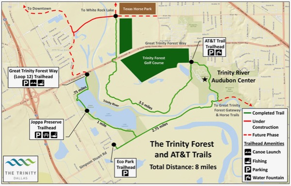
This Trinity Forest and AT&T Trail 2015 map still shows Lemmon Lake, which has since drained due to a dam breach. Courtesy of City of Dallas. See larger version of map.
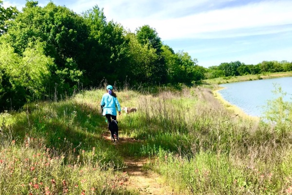
Ella walks a dirt trail along the Big Dig. Photo by Amy Martin.
LOOP 12/GREAT TRINITY FOREST WAY TO ELAM ROAD & BEYOND
Hiking companions: Kristi Kerr Leonard and Ella St Clair
Season: Mid-spring
Distance: 4.5 miles
Time: 3.5 hours
THE HIKE
The things I find surfing the satellite view of Google maps. At the end of Elam Road, in a small area wedged between the Texas Horse Park and the northern section of the Trinity Forest Golf Club, I notice a small parking lot and circular turnaround. The property next to it shows on Google Maps as “Trinity park and club soccer park.” It begs a hands-on look.
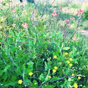 Wildflowers dot the trail in April. Photo by Amy Martin.
I recruit Ella and Kristi to explore (using socially distancing protocols) the northern TFT section. We gather at the lot with our various dogs: my Sally coonhound; Ella’s Pointer Sisters, Ginger and Maryanne (a pop culture collision!); and Kristi’s small Chloe.
From the parking lot, the TFT goes east between two sections of the sprawling Texas Horse Park. It’s a bland terrain of clipped pasture and scattered trees. The “Trinity park and club soccer park” is nowhere to be seen.
We head west along the cut-off terminus of Elam Road past a large pond. This must be the Big Dig! The city felled hundreds of stately bois d’arc, oak and pecan trees despite multiple promises not to do so. The reason? A borrow pit the size of an NFL football stadium to provide dirt for the golf course’s creation.
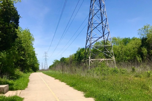
A stark electrical tower corridor leads to the forest trail. Photo by Amy Martin.
The Big Dig, as dubbed by naturalists, filled with water that tested as tainted. Heavy rains caused it to breech almost to the Trinity. A formal pond with dam had to be installed, felling more trees. The pond’s artificial square outline is jarring; its shores are devoid of plant life. With water still as a stone, it seems like a bathtub. A handful of people are fishing from it.
We pass a sweet little wildflower enclave from which emerges a narrow dirt trail that loops around the pond. Next comes the electrical tower corridor with a northbound dirt path that’s already lost in ragweed. We turn south on the TFT, but before doing so we spy a wide dirt trail snaking through a beautiful spacious forest. Intriguing!
Yet we must forge on and head south on the TFT. The golf course spreads to the east and deep forest to the west, sometimes down a steep slope. Even though the utility-corridor blandness is enlivened on this day by profuse wildflowers, we hit our mark and hustle back to the tantalizing forest trail.
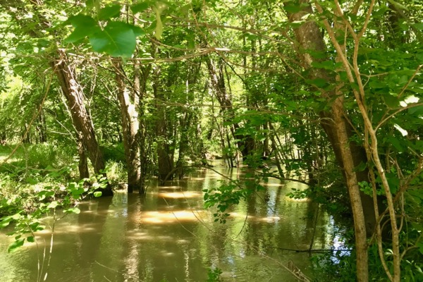 Hikers will encounter swampy areas, typical of a bottomland forest. Photo by Amy Martin.
The Imperiled Peace of the Forest
The wooded trail imparts an immediate peace. Real nature at last! The dogs discover a swampy area and start to splash. The forest’s spaciousness is due to bulldozing trees for a proposed concrete trail to come through. If that happens, the forest will be cleared even more. It’s like walking through a dissipating dream.
We hike to the Trinity River, coursing strong yet silent. Kristi chats up a fisherman as I gaze to the opposite bank. Plans are to connect the paved trail through the Lower Chain of Wetlands on the other side to here. A contractor went rogue and bulldozed down dozens of mature bur oaks over there. In the gap along the shore, a mess of willows have sprung up, a poor replacement.
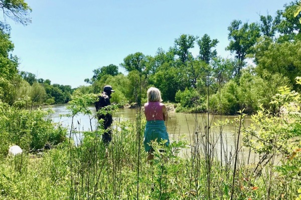 Kristi talks to a fisherman on the Trinity River. Photo by Amy Martin.
To complete the connection, a pedestrian bridge is planned here in this place of soft silt and frequent floods. Debris is visible six-feet up in nearby trees. Deep in the grass and greenery are several rebar tubes probably 20 yards long. Super deep holes would be bored and filled with concrete and rebar for bridge supports. The thought of what heavy construction equipment would do to the area is horrifying.
A Riverside Amble
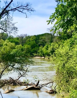 The Trinity River looking north. Photo by Amy Martin.
Waiting in the shade while Kristi chats, Ella and I stumble across a riverside path. The narrow dirt trail is barely visible amid the lush plant life. We beckon to Kristi and head north, keeping the river to our left.
After a while, the greenery abates and the trail becomes clear. It enticingly unfurls as far as we can see through an idyllic sea of grass beneath scattered large trees. It radiates with the pastoral spaciousness of woods that get regularly swept by floodwaters. It finally feels like the Great Trinity Forest.
We meet only fishermen on the trail who warn us of snakes. There are ponds, large and small, and gentle sloughs full of water. These are wet woods, genuine bottomland forest, shaped by river and rain. The deep and rich riparian soil arises from numerous decades of abundant decaying leaves and fertile river silt deposited by floods.
In Search of White Rock Creek
Kristi and Chloe depart. Ella and I forge on, taking advantage of many side trails to get a river glimpse. I check our location status on Google Maps satellite view, impressed at the strong signal deep in the woods.
“If we keep going, we’ll hit where White Rock Creek meets the river,” I implore.
Ella is up for the adventure. Don’t even have to ask the dogs.
Seeing the confluence of White Rock Creek is a pilgrimage to me. I grew up on one of its feeders. Endless hours of childhood spent following it to the creek with its dramatic steep chalk-rock sides. A chance to come full circle to what shaped me as a young naturalist.
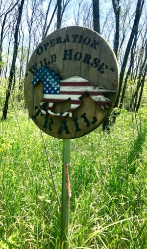 We continue north, but the trail slowly pulls away from the river. Nearly two miles down the trail, an old wooden sign identifies our route, or perhaps the area, as “Operation Wild Horse,” an equine fundraiser associated with veterans. I check Google maps. We missed the creek confluence and are heading toward a long slough, a good place to turn around.
The narrowing trail takes a few hard turns until we feel there’s nowhere else to go. We hear Sally snort and see her about five yards to the left in the thick grass. Her face seems to say, “Here’s the trail, dummies.”
A bit more meandering until a verdant watery morass blocks our way and we head back. Sally, who is 90 percent nose, rushes to the head of the line. She obviously considers herself the trail leader. No need to check Google maps anymore; Sally will lead us back just fine.
Close to the trail’s end, we spy an incongruous bench deep in the grass next to a pond, offering rest with a view. The dogs roll in shady grass. It’s just so perfect. We are sad to go home.
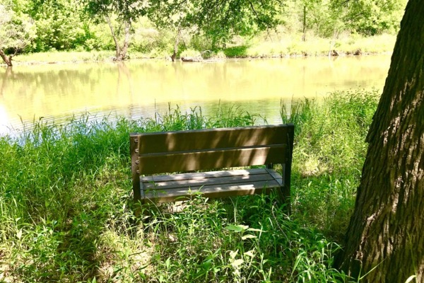 A bench near the trail's end offers a great place to hang. All photos by Amy Martin.
Trinity Forest and AT&T Trail
About: Trail featuring more than eight miles of paved trails linking Trinity River Audubon Center, Texas Horse Park, Trinity Forest Golf Club, and Joppa Preserve. Located in the Great Trinity Forest between Simpson Stuart Road and Elam Road just east of I-45, with Loop 12/Great Trinity Forest Way bisecting the area. See map.
Access:
AT&T Trail Trailhead: Located on the road to Trinity River Audubon Center. Illuminated clean parking lot, lightly patrolled on nights and weekends.
EcoPark Trailhead: Clean parking lot, but in area of little oversight on nights and weekends.
Joppa Preserve Trailhead: Access is off TX 310, also known as S. Central Expy., which parallels US 175 for a while. Turn on River Oaks; look for WW Roland Trucking. Go 3/10 of a mile. Only trailhead with bathrooms.
Trinity Forest Way (Loop 12) Trailhead: Odd parking lot below Loop 12 in area of little oversight. Very close to the river; parking lot floods occasionally. Look for the wildlife-warning sign with images of tigers and cobras.
Great Trinity Forest Features:
TRINITY FOREST & AT&T TRAIL SERIES
Part 1: Joppa Preserve to Trinity River Audubon Center. (SEE INSTALLMENT ABOVE)
Part 2: Trinity River Audubon Center & Joppa Preserve to Loop 12/Great Trinity Forest Way
Part 3: Loop 12/Great Trinity Forest Way to Elam Road (SEE INSTALLMENT ABOVE)
Stay up to date on everything green in North Texas, including the latest news and events! Sign up for the weekly Green Source DFW Newsletter! Follow us on Facebook and Twitter. Also check out our new podcast The Texas Green Report, available on your favorite podcast app.
Author

AMY MARTIN
Amy Martin, a journalist and writer for more than 40 years, is a senior reporter for GreenSource DFW. Her latest book, "Wild DFW: Explore the Amazing Nature in and round Dallas-Fort Worth,” (Wild-DFW.com) will be released by Timber Press in July 2023. She is currently creating a biographical website (NedFritz.com) of Ned Fritz, Texas' most famous environmentalist. Her prior book was "Itchy Business: How to Treat the Poison Ivy and Poison Oak Rash, Prevent Exposure and Eradicate the Plant.”(Itchy.biz) She was contributing editor for the national magazine Garbage (recycling and features), and has written for TheaterJones (comedy and cirque), Senior Voice (The Aging Hippie column), Dallas Morning News (recycling), Dallas Times Herald (performing arts), and Dallas Observer (music and comedy). For a dozen years, Martin also operated a popular alternative news service called Moonlady News, earning her the nickname Moonlady. She may be reached through Moonlady.com.