

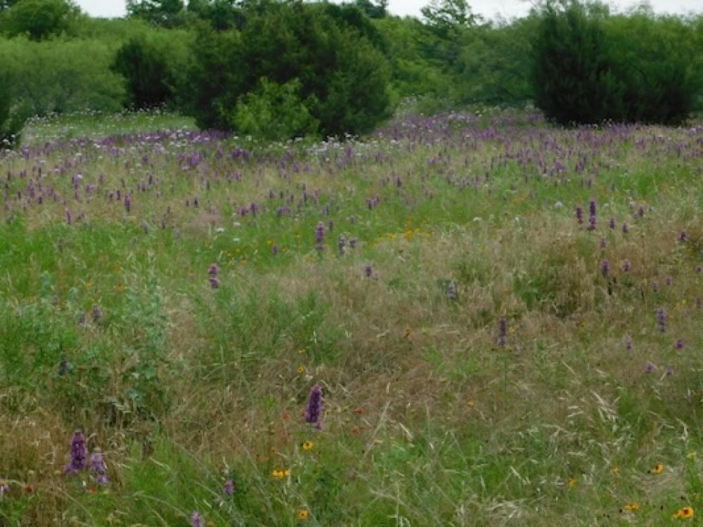
In spring, the prairie at LBJ National Grasslands comes alive with flowers. Photo by Michael Smith.
Feb. 2, 2024
Many North Texans have never visited the Lyndon B. Johnson National Grasslands (LBJNG), located right here in our own “backyard” — about 60 miles north of Fort Worth. Because it’s a patchwork of parcels and contains no formal entrance, it can be daunting to navigate. But that shouldn’t keep you from enjoying this special untamed landscape. Here’s a quick guide.
QUIET PLACE
The LBJ National Grasslands is one of 20 national grasslands located within the western states of the U.S. Most of them are within the Great Plains, the huge region between Canada and Texas, where prairies have largely been converted to agriculture. All 20 national grasslands are administered by the U.S. Forest Service.
The LBJNG is scattered in parcels north of Decatur — far enough from Fort Worth so that the sounds of nature are easier to hear.
On a recent visit, we looked out onto a prairie gently sloping down towards the oak woodland. Native grasses, like little bluestem and Indiangrass, wore autumn shades of straw, ivory and cinnamon. As the path turned from the prairie into woodland, armadillos bustled through the undergrowth in search of tasty insects.
Some of the oak leaves were ablaze in brilliant shades of red and orange. On one walk in the quiet woodlands, a friend’s daughter noticed that she could hear a leaf when it fell from the tree. Yes, I've noticed that too, and it seems magical in a world where many of the sounds come from highways and air conditioners.
PATCHWORK OF PARCELS
The LBJNG encompasses 20,250 acres. However, that land is divided into 67 small to medium-sized units with private ranch land between most of them. Unit number one is a little rectangle containing 84 acres northwest of the town of Alvord. Unit number 31, with 2,969 acres, is much bigger. Trails for hiking or horseback riding wind through the units, and there are little ponds and a few lakes here and there.
Small county roads weave through the area and there are gravel Forest Service roads within many units. However, there is no “main entrance” and few signs, so it is best to go with an experienced LBJ Grasslands visitor or bring a map. A good paper map is sold for $14 at the LBJNG office, 1400 N. Hwy. 81/287, Decatur, TX 76234 (call ahead, as the office is currently only open Monday, Thursday and Friday. A trail map is available online for free. Phone service, for calls or for Google Maps, is variable and a few places have no service.
WHERE GRASSLANDS MEET WOODLANDS
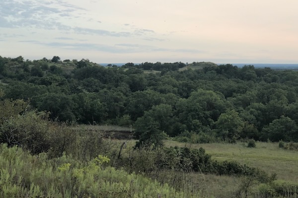 A sunset view from a ridge in Unit 7. Photo by Michael Smith.
Don’t expect an ocean of grasses all the way to the horizon. The LBJ National Grasslands is located at the edge of the Western Cross Timbers, an ecoregion dominated by post oak and blackjack oak with patches of prairie swirled in to make a beautiful stew.
You will find patches of prairie with grasses and flowers, places where the trail winds through oak and juniper woodland and savannahs where grasslands are dotted with trees or small clusters of trees.
You might wander down the trail and suddenly find yourself walking on a carpet of pine needles under a grove of loblolly pines. Long ago, the Forest Service planted these pine trees in several spots. Was it just to see if they would grow? No one seems to have a clear answer, but it was not to try to replace the oaks and prairies. While they don’t belong here, the pine groves are a beloved part of the grasslands. A couple of them are popular camping spots.
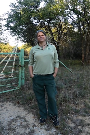 Reese Sewell, a Supervisory Rangeland Management Specialist with the Forest Service. Photo by Michael Smith.
I spent some time at the grasslands with Reese Sewell, a Supervisory Rangeland Management Specialist with the Forest Service.
“The pines were planted here in the 1960s just in a few places,” she said.
Some people wonder if the pines will take over, but Sewell did not think so.
“The pines do spread with a few volunteers [seedlings that come up on their own], but where the pines were planted there is almost zero regeneration.”
She said that the pines are so close together that their crowns shade out new growth.
“I think there will always be some pines but they’re not going to be solid stands. Maybe pine-oak savannah.”
They are out of their natural range here and they have to cope with periodic drought. The drought stresses the trees and opens them up to infestation by a tiny beetle known by part of its scientific name: Ips.
“Normally Ips beetles are scavengers, can smell out a stressed tree, a lightning-struck tree and will go to it,” Sewell noted.
We examined a loblolly pine in one of the groves. The bark was peppered with tiny holes made by beetles emerging from the tree. Sewell explained more about the beetles and the tree’s defenses: The beetles “get into the cambium [the growing tissue under the bark]. But if the tree is healthy, it will push the beetles out with pitch.”
The pitch or pine sap could block the insect. Sewell found none of this on a tree we examined. “It didn’t even put up a fight,” she said.
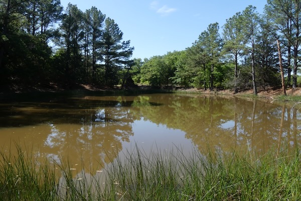 A pond within the pine grove in Unit 30. Photo by Michael Smith.
A LONG, SOMETIMES TRAGIC HISTORY
People have lived in this region for thousands of years. The earliest Paleo-American cultures were followed by indigenous cultures such as the Caddo people, who domesticated plants for farming and developed increasingly sophisticated tools. And then the land was claimed by a new people. Sewell said that when the Comanches got horses and moved down here they became the dominant group of Native Americans.
In the 1700-1800s, Europeans claimed the land and white settlers moved westward, establishing ranches and farms on land that the Comanches considered theirs. At times there were Comanche attacks and raids on settlers followed by counterattacks, as well as skirmishes and battles between bands of Comanche and U.S. soldiers. Eventually the Comanche and other indigenous peoples were pushed out.
With growing numbers of white settlers, more of North Texas was used for farming and ranching. Overall across the Great Plains, 18 million acres of virgin prairie were broken and cultivated after the Civil War.
This conversion of grasslands into farmland continued until the 1930s. Severe drought arrived, and unprotected topsoil eroded and was picked up by the wind in enormous dust clouds. The Great Plains became the “Dust Bowl.” This, along with the Great Depression, drove many farmers into debt and poverty, and many left their farms.
A series of federal government efforts attempted to stop the damage to the land and provide relief to the people. This was the next part of the history of the LBJ National Grasslands. It was summarized in a draft environmental statement from the U.S. Forest Service in 1974 concerning what was then known as the Caddo-Cross Timbers National Grasslands:
“These lands were purchased by the federal government from private individuals after passage of the Bankhead-Jones Farm Tenant Act of July 22, 1937. These lands were called Land Utilization Projects and administered by the Soil Conservation Service until Dec. 20, 1953. The lands were then transferred to the administrative jurisdiction of the Forest Service.” (p.15)
In the hands of the Forest Service, the grasslands will not be sold off or developed, and their ecological health is in the hands of professionals like Sewell. But according to the law, Forest Service land must be made available for multiple uses. That includes gas drilling at LBJ Grasslands. Hunting and fishing are allowed, as is cattle grazing. The Multiple-Use Sustained-Yield Act of 1960 provides for “renewable surface resources of the national forests” to be managed “so that they are utilized in the combination that will best meet the needs of the American people.”
GRAZING AND FIRE REQUIRED
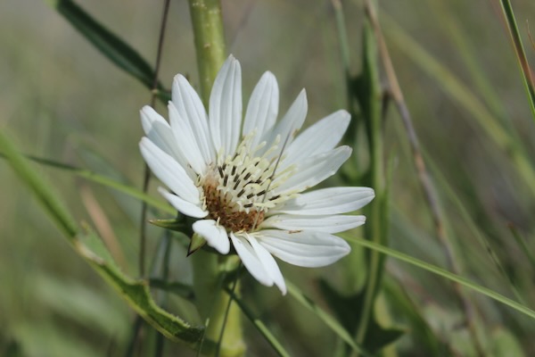 Summer flowering of white rosinweed, also known as compassplant. Photo by Michael Smith.
Healthy grasslands must occasionally be “disturbed” in order to remain healthy.
“Our native species are adapted to specific disturbances – fire, grazing, and drought,” Sewell said. “Those three things are primary drivers for the ecosystem, and plants are adapted to it.” There was a time when nature and Native Americans took care of all that. These days, the Forest Service carefully plans the use of fire — prescribed burns — in certain patches of the grasslands. Since there are no bison to graze the prairies there, the LBJ National Grasslands depends on short periods during which cattle graze the grasses and other plants there.
The cattle are rotated from place to place, but that’s only one tool in managing where the cattle stay, Sewell told me.
“The research shows 75 percent of their time is on the most recent burn areas. Also, they will walk further away from water [for opportunities to graze on new growth after a fire].” Maintaining a prairie is a constant tug of war between fire and grazing versus attempts by problem plant species to take over.
“Problem” might mean woody plants like bushes and trees or plants that don’t belong there (like Chinese bush clover, genus Lespedeza).
The disturbances set all kinds of things in motion; for example, Sewell said that cattle will graze new growth of Lespedeza after a fire but ignore them once they are established. They also graze new growth of greenbrier, the thorny vine that becomes a thicket if unchecked. And so, after the Forest Service does a prescribed burn of a patch of land, it’s a perfect time to bring in the cows.
KEEPING IT WILD
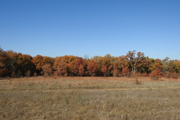 A prairie and woodland in Unit 29 in autumn colors. Photo by Michael Smith.
The Forest Service can plan prescribed burns and arrange to rotate cattle grazing, but they cannot control what happens outside its boundaries. If LBJ Grasslands units are scattered among healthy private ranchland, the grassland units benefit because they are less isolated, biologically.
But private individuals may be more likely to sell their land as circumstances change, they get older, or the challenges of caring for agricultural land increase. Houses with lawns and driveways are sprouting up in more of Wise County, and the units of the grassland can become more fragmented and that makes them less healthy.
“Conservation easements are the only hope I see for keeping a wildness to these grasslands and also have a functioning local economy for agricultural and grazing livestock,” Sewell said, as we talked about keeping the LBJ grasslands healthy.
If more ranchland is sold and divided into lots for houses, roads and traffic increase, then gas stations and stores sprout up, and sprawl would turn the LBJ National Grasslands units into little islands of prairie and woodland.
The Native Prairies Association of Texas defines a conservation easement as “an agreement between a landowner and a private organization or land trust such as NPAT,” for the purpose of preserving some aspect of the land. The property owner still owns it and could sell it, but the agreement would still be in force. The agreement might specify, as an example, that it cannot be developed for residential or commercial purposes. Conservation easements can bring significant tax benefits to the property owner.
A WALK IN THE WILDNESS
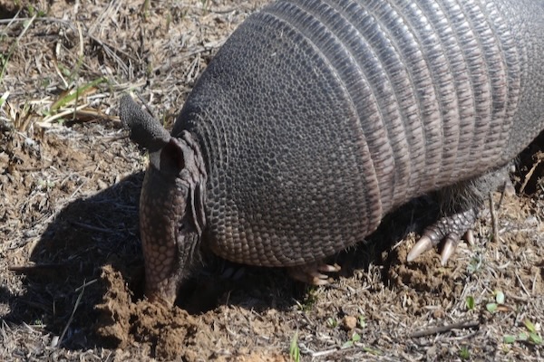 A nine-banded armadillo seen in the grasslands in March of last year. Photo by Michael Smith.
There’s no main entrance and the trails are mostly primitive. The appeal of LBJ Grasslands is for those who want to be immersed in nature, without man-made amenities.
“This place has really opened my eyes to appreciating grasslands and prairies, something that I did not have less than a year ago,” said Sheryl Joiner of Lake Worth. “A lot of people don't understand the beauty of the grasslands until you're actually out here.”
She said she was surprised that so few people knew that there was a national grassland so close to the Metroplex.
“This place has really opened my eyes to appreciating grasslands and prairies, something that I did not have less than a year ago,” said Sheryl Joiner of Lake Worth. “A lot of people don't understand the beauty of the grasslands until you're actually out here.”
Alaina Graff of Springtown added, “Almost any time I've been out here, the busiest it’s been is when I've passed one or two other people walking. It helps that sense of being here by yourself, and the quiet, and the ambience of it all.”
If you want to visit but would like a little guidance, there are a couple of options. One is to go to Mary Curry’s website and contact her to join one of her “First Wednesday” walks. Curry leads small groups to explore some part of the grasslands on the first Wednesday of the month. She has been doing this for a long time.
“It’ll be 20 years in February,” Curry said.
Her website has a number of downloadable pdf books on the plants and animals of the North Texas area.
Another option for a guided visit is the LBJ Grasslands Project, which is not affiliated with the Forest Service. Kayla West and I started the Project as a Facebook group in December of 2021 and we have periodically led walks or arranged for others to lead walks there.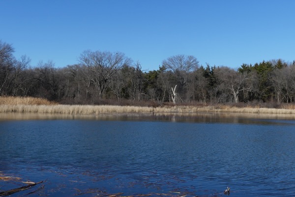
Black Creek Lake in Unit 47 seen in winter. Photo by Michael Smith.
LBJ National Grasslands
About: The national grasslands encompasses 20,250 acres and is divided into 67 small to medium-sized units with private ranch land between most of them. Unit number one is a little rectangle containing 84 acres northwest of the town of Alvord. Unit number 31, with 2,969 acres, is much bigger. Trails for hiking or horseback riding wind through the units, and there are little ponds and a few lakes here and there.
Map: Here's a printable map. A good paper map is sold for $14 at the LBJNG office, 1400 N. Hwy. 81/287, Decatur, TX 76234 (call ahead, as the office is currently only open Monday, Thursday and Friday. A trail map is available online for free.
Cell Service: Phone service, for calls or for Google Maps, is variable and a few places have no service.
Guidance: Mary Curry has been hosting “First Wednesday” walks for 20 years. Contact her to sign up. In addition, he LBJ Grasslands Project, founded by Michael Smith and Kayla West, offers a lot information on their website. The group also hosts occasional walks. See their LBJ Grasslands Project Facebook group for scheduled events.
RELATED ARTICLES
Urban prairie burned again in Fort Worth — here’s why
Stay up to date on everything green in North Texas, including the latest news and events! Sign up for the weely Green Source DFW Newsletter! Follow us on Facebook, X and Instagram. Also check out our new podcast The Texas Green Report, available on your favorite podcast app.
Author

MICHAEL SMITH
Michael Smith is an Arlington-based writer and naturalist. He is author of two books on reptiles and amphibians and a forthcoming book is on mindfulness in nature. He is retired after a 35-year career as a Psychological Associate, but still leads mindfulness walks and teaches nature journaling. See https://livesinnature.com or www.MSmith-info.page, or contact him at masmith.tx@gmail.com.