

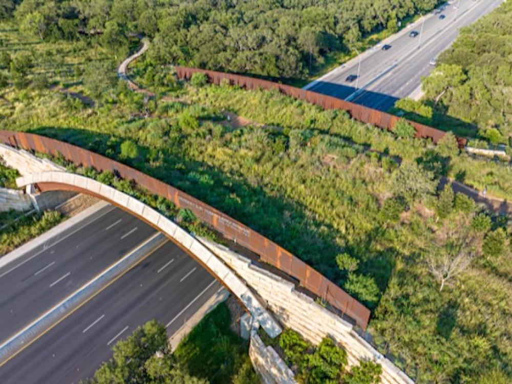
San Antonio's Phil Hardberger Park features a unique land bridge that accomodates both wildlife and park visitors. Photo by Justin Moore Airborne Aerial Photography.
Feb. 8, 2024
![]() A park in San Antonio offers a creative solution to habitat fragmentation that’s garnered the attention of wildlife conservationists across the U.S.
A park in San Antonio offers a creative solution to habitat fragmentation that’s garnered the attention of wildlife conservationists across the U.S.
Habitat fragmentation is a common problem for wildlife caused when humans divide natural landscapes, typically with streets and highways. As a result, wildlife can be cut off from needed resources or else they travel by the same routes, which can lead to collisions that are tragic for both wildlife and humans.
In the U.S. it is estimated that there are one to two million vehicle collisions with deer and other larger wildlife every year. A collision between a vehicle and a deer results, on average, in economic costs of $9,175, according to a Washington State Department of Transportation study.
These collisions also result in the loss of human lives, and among wildlife, the future of some species can be affected. There are 21 species in the U.S. whose survival is threatened by road mortalities, including key deer in Florida, bighorn sheep in California and red-bellied turtles in Alabama.
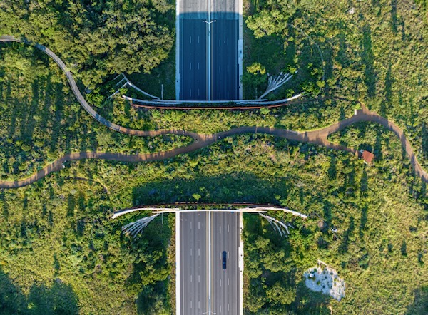
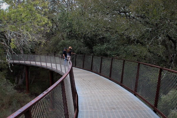
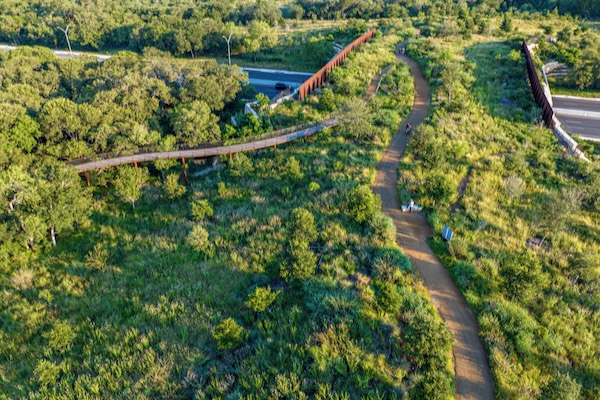
In San Antonio, Phil Hardberger Park, a 330-acre nature preserve, was bisected by a busy six-lane highway. The city solved the geographical challenge by constructing the Robert L.B. Tobin Land Bridge. The land bridge, which opened in December 2020, allows wildlife and people to safely cross the Wurzbach Parkway. It aslo serves as an extension of the park habitat, with features making it both wildlife and human friendly.
PARK BEGINNINGS
 The Robert L.B. Tobin Land Bridge connects the East and West sides of the park. Photo by Justin Moore Airborne Aerial Photography.
I visited Hardberger Park in November and met Teresa Shumaker, associate director of the Phil Hardberger Park Conservancy, and Wendy Leonard, the assistant manager of Parks and Recreation Natural Areas. They gave me a tour of the park and told me the story of the land bridge.
The park, which opened in 2010, is located in the northern part of the city, outside of the inner loop (Interstate 410) but below Loop 1604. The land has never been developed, but once was a dairy farm.
“In 2006, Phil Hardberger was mayor when the land came up for sale,” said Shumaker. “He came out the same day that he heard it was available.”
Within 60 days, the first 311 acres were bought by the city, with additional acres acquired from Wal-Mart as part of a mitigation in 2007.
Some of the land had already been sold to construct Wurzbach Parkway, a multi-lane expressway, which divided the park's East and West sides, as they are referred to by the city. (On the map, the two sides are oriented northeast and southwest.)
Biologists and conservationists worry when habitat is fragmented because it traps communities of animals and plants in little patches.
The land bridge, completed in 2020, was part of tbe park’s master plan to allow wildlife and people to move between the two halves of the park.
Corridors that allow animals to move about are very valuable, and the land bridge is a corridor that gives coyotes, raccoons and other animals access to more habitat.
For species living in the West part of the park, the bridge was especially valuable.
“The beautiful thing about this land bridge is that the [West] part was isolated,” Shumaker said. "But the [East] part connects with greenways that run for 30 miles. So when the land bridge connected the two parts of the park it also connected wildlife with those corridors.”
Bigger areas to move around in, mean healthier wildlife.
DESIGNING THE PARK
 Volunteers planted nearly 40,000 plugs of native grass to restore the savannah behind the Urban Ecology Center. Photo by Michael Smith.
My tour of the park started at the Phil Hardberger Park Conservancy’s Urban Ecology Center, which opened in 2013, earning GOLD LEED certification.
The Savannah (grassland with scattered trees) is located directly behind the Center. A lot of staff and volunteer effort went into restoring this area. Without grazing by bison or cattle, and without fires periodically burning off woody plants, grasslands gradually give way to trees and shrubs.
“You can see in aerial photos how the woodlands take over, especially without grazing pressure once the cows left,” Shumaker said. “Wendy and others had an amazing volunteer workday in 2009 before the park opened to plant native grasses and restore the savannah.”
Leonard recalled that more than 400 volunteers (called the “Weed Warriors”) planted 38,000 plugs of native grass.
On a sunny day when visitors look through the savannah, they can see flashes and twinkles of light through the tall grasses. It is an art installation called Golden Age, created by Anne Wallace. Irrigation wheels were turned on their side and hung with row upon row of big shiny sequins. Shumaker explained that when settlers first moved through Central Texas, wildfires were a natural part of the prairies and savannahs.
The sequins on the wheels catch sunlight, making the tops of the grass heads appear to sparkle.
“Very similar to what it would look like if you were to see a wildfire happening in the distance,” said Shumaker.
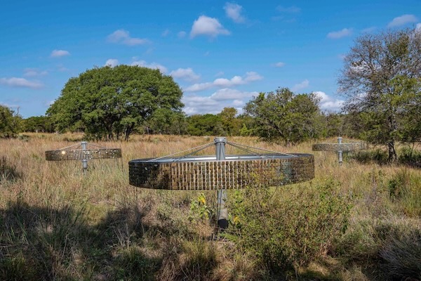 An art installation by Anne Wallace called "Golden Age" is meant to mimic the flickering light of fire on the prairie. Photo courtesy of the Phil Hardberger Park Conservancy.
The park includes bits of several ecoregions that come together in San Antonio. Shumaker described several plant communities, including live oak and cedar elm in the savannah, mesquite and Ashe juniper nearby, and pencil cactus and prickly pear in other places.
“We’ve got Blackland, Edwards Plateau, and some South Texas thorn scrub,” she said. “Less than 20 percent of the acreage is developed for people.”
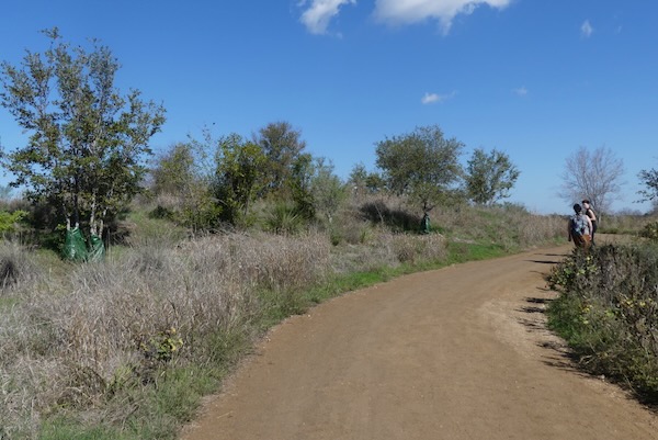
As we approached the bridge, we saw trees with a sort of vinyl zip-up bag wrapped around the base of the tree. The summer had been so hot and dry that the park used these “gator bags” to water the trees. When filled, each one distributes about 20 gallons of water over a four to six-hour period. For some trees, it helped and for others it was not enough.
When rain does come, the park has a plan for that. To collect needed water and minimize severe runoff from the land bridge, they have installed French drains that bring water to a buried 250,000 gallon cistern. That water can then be distributed to the trees or wherever needed.
A hill was created to form the land bridge. The original top soil with native seeds was preserved and put back. On the left, "gator" bags helped trees survive during last summer's extreme heat. Photo by Michael Smith.
THE LAND BRIDGE
Designing and building the Robert L.B. Tobin Land Bridge cost $23 million. Thirteen million was raised by the city in a bond election, voted for by the public. The bond proposal included a couple of wildlife viewing blinds on the bridge, each designed by local artists.
Shumaker said one of the challenges of the project was that a hill had to be created to form the land bridge.
“When they were preparing the footprint, they took all the native soil, scraped it and stored it on the side.”
The soil contained seeds of the native plants that belong in the park. And so, when they had the bridge structure built and were ready for landscaping, they brought the native soil back in already containing seed for plants found in the area.
As we walked up over Wurzbach Parkway, the large barriers at either side block the view of the roadway and most of the sound. It really was like walking up a hill, not a bridge.
“This is the first land bridge in the U.S. that we are aware of that is designed for the multiple use of both people and wildlife," Shumaker said. "You see that the person trail is to the side, and then there is an earth berm in the center that blocks the view, and then there’s a wildlife corridor on the other side.”
WILDLIFE CROSSING
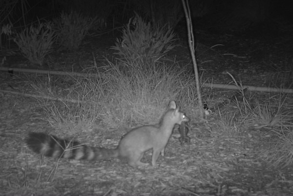 A ringtail carrying a Texas spiny lizard is captured on a trail cam on the R.L.B. Tobin Land Bridge in 2021. Courtesy of City of San Antonio.
Trail cameras have documented the success of the wildlife crossing. Before the land bridge had been open for one year, the cameras captured every mammal species known to occur in the park.
“We’ve got raccoons, opossum, white-tailed deer, gray fox, bobcats, and we discovered that there are two packs of coyotes living in the park. Oh, and a picture of a ringtail catching a Texas spiny lizard.”
This last critter, the ringtail, is a cat-sized mammal that looks a little like a small fox with a long tail ringed in dark and light fur. As the tail might suggest, they are in the same family with the raccoon. Ringtails have been found all over the state but may be most common in Central Texas and the Trans-Pecos. They are excellent climbers and are active only at night, so they may not be noticed by many people. Ringtails like rocky environments with ledges and caves, and will also live in tree cavities and hollow logs.
With coyotes and other wildlife living in the park, do they ever encounter people while crossing the land bridge? Is there any human and wildlife conflict? Both of my guides said that there have been no problems.
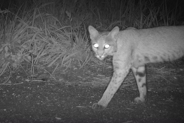 A bobcat strolls across the land bridge in this trail cam image from 2021. Courtesy of city of San Antonio.
“People may see sick or injured wildlife, such as when we had a coyote with mange,” Leonard said. “We also sometimes may have an injured deer that will come around, but no adverse interactions with people.”
And that’s good news in a park that sees about 1,000 visitors a day.
A group of experts has been touring the U.S. looking at different wildlife crossings. In September, they met with folks from Hardberger Park. The group included Beth Pratt, a regional executive director with the National Wildlife Federation, known for advocating for the bridge in Los Angeles used by cougars.
“She said they had been watching us the whole time and they designed their land bridge similar to ours, except that theirs is just for wildlife,” Shumaker said.
SKYWALK
 The 1,000-foot skywalk, completed in 2021, gives visitors a bird's eye view of the treetops. Photo by Kat Oliver.
Right in the middle of the land bridge, the human path divides and a new path bends away a little to the northeast to take visitors into the nearby tree canopy on the Skywalk.
We felt like birds flying low among the tops of mesquite and live oak trees, gradually dropping until the skywalk meets the trail on the north part of the park. As it was being built, staff worked closely with contractors to leave the trees as intact as possible so that the walkway would thread its way through upper tree branches.
Leonard described a wonderful surprise when an inspector reached from the skywalk into a cavity in a tree limb to see if it was rotted.
“He suddenly heard hissing, pulled back and saw a barred owl’s head pop out at him. We are watching to see if she comes back to nest.”
We talked about the other birds seen in the park, like ladderback woodpeckers and a crested caracara (sometimes called the “Mexican eagle,” though it is technically a tropical falcon). And then someone said, “There she is!” It was the barred owl, flying through the tree canopy at about eye level. It looked like she was back!
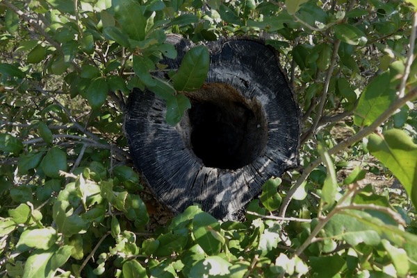 A tree cavity in which a barred owl was seen from the Skywalk. Photo by Michael Smith.
VENERABLE OAK
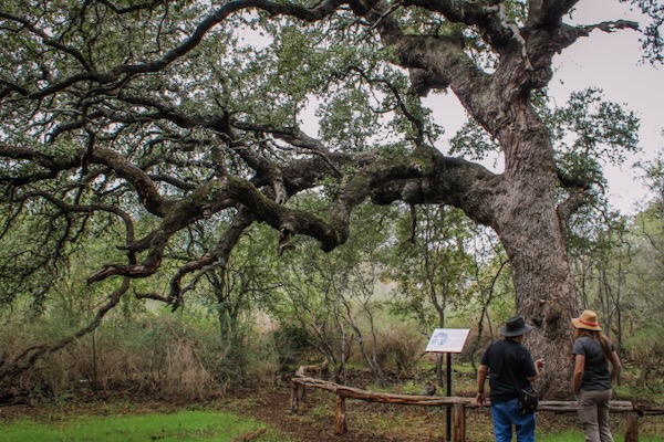
On the other side of the land bridge, we passed through thickets of fragrant white brush whose branches create corridors where cottontails run. We came to a small trail that winds through live oaks to “Phil’s Tree.”
“This tree started the conservation of this property,” Leonard said.
Mayor Hardberger was out walking and saw this enormous old live oak, estimated at 400 years old and determined that this place must be preserved.
“We have people who come here and pray, we have people who come here and feed birds and meditate — it’s a very magical place for park users.”
It was quiet in this spot, and the sun filtered through leaves to give a clear, soft light. Nearby, a spotted towhee had been scratching at the ground and a bunch of black-crested titmice jumped back and forth in the brush.
 GSDFW reporter Michael Smith and Wendy Leonard of the San Antonio Parks and Recreation Department in front of the live oak known as "Phil's Tree." Photo by Kat Oliver.
“One of my favorite stories of the tree happened when we partnered with a new school in town for a field trip and brought them out," Shumaker said. "There were two teachers who hung back afterwards, and one of them was praying and one of them was crying. Our intern went up and spoke to them, and they said they had been reticent to come out because there are so many logistics to bringing kids out on a bus for a field trip. They weren’t sure if they were going to get much from it. ‘But,’ the teacher said, ‘being in the presence of this tree, being out and seeing the kids — I see the importance.’”
If you are in San Antonio and can visit Phil Hardberger Park, walking over the land bridge and sitting beside Phil’s Tree, you may see what they saw. You might feel some of the same awe and gratitude felt by those teachers.
Phil Hardberger Park
About: The 330-acre natural area, which opened in 2010, features an Urban Ecology Center and the Robert L.B. Tobin Land Bridge, which opened in December 2020. The Skywalk opened in 2021.
Where: Northern San Antonio
East Entrance: 13203 Blanco Road
West Entrance and Urban Ecology Center: 8400 N.W. Military
Amenties: Other features in the park include unpaved trails, picnic areas, demonstration gardens, play areas, dog parks and a Bird Water Feature.
Stay up to date on everything green in North Texas, including the latest news and events! Sign up for the weekly Green Source DFW Newsletter! Follow us on Facebook, X and Instagram. Also check out our new podcast The Texas Green Report, available on your favorite podcast app.
Author

MICHAEL SMITH
Michael Smith is an Arlington-based writer and naturalist. He is author of two books on reptiles and amphibians and a forthcoming book is on mindfulness in nature. He is retired after a 35-year career as a Psychological Associate, but still leads mindfulness walks and teaches nature journaling. See https://livesinnature.com or www.MSmith-info.page, or contact him at masmith.tx@gmail.com.